If you've noticed, I added a TripIt badge to the sidebar, which shows that I'm going to Kolkata (Calcutta) on Thursday. This inspired me to create a map of West Bengal, complete with inset map showing the location of West Bengal in India:
I used two data layers, one for the map of West Bengal, and the other for the inset map.
You may download a zip file containing the map of West Bengal in JPEG, PDF, and ArcMap (.mxd) formats.
Tuesday, February 26, 2013
Friday, February 22, 2013
#India: areas under irrigation map
After being unhappy with the maps in Brahma Chellaney’s book Water: Asia's New Battleground, I decided to create my own map of areas under irrigation in India.
For this map, I used irrigation data from the global map of irrigation areas from AQUASTAT, the FAO's global information system on water and agriculture. Data shows the percentage of irrigated land per 5 arcmin cell, which is approximately 8547 hectares: someone check my calculations!
Global Map of Irrigated Ares. The Ganges River basin is the most irrigated area in the world.
You may download the map of irrigated areas in India in JPEG format or the map of irrigated areas of India in PDF format. Alternatively, if you would like to muck around with the map itself, download the ArcMap document showing irrigated areas of India.
Location:
India
Thursday, February 21, 2013
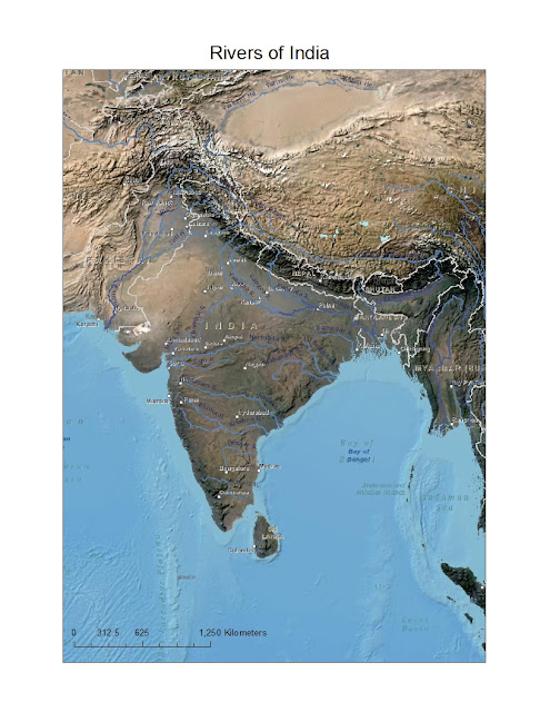
Rivers of India with Landsat imagery
Here is another map I created of the rivers of India, this time with Landsat imagery:
You may download the map of the rivers of India in JPEG format or the map of the rivers of India in PDF format. Alternatively, if you would like to play around with the map itself, download the ArcMap document showing the rivers of India.
Location:
India
Friday, February 15, 2013
Tales from River Brahmaputra
Namaste,

I'm only on page 60, and Tales from River Brahmaputra by Tiziana Baldizzoni is already proving to be a better book than Rivers of India. It has a superior pressing and stunning photos. It's easy to overlook the text, which is filled with lore about the Brahmaputra.
It seems to be a little thin on the coverage of the river's course through India.
Reproductions of antique maps are provided on the back side of the front and back covers.
View all my reviews
Labels:
Bangladesh,
Brahmaputra,
China,
India,
rivers,
Tibet
Location:
Brahmaputra River, Assam
Thursday, February 14, 2013
Rivers of India
My rating: 2 of 5 stars
Cheap pressing. Simplistic text. Single fold-out map features rivers symbolized with thick blue lines. Would have liked more detailed maps for each of the chapters.
View all my reviews
OK, I would have liked better maps, so I created my own with data in ArcMap, using free data from Esri:
 |
| Rivers of India |
The map has been formatted to a standard 8.5" x 11" sheet (US).
You may download the JPEG image of Rivers of India or the PDF file of Rivers of India from Google Drive. One problem is the overprint of place names, but I couldn't toggle the options on and off. :-(
Alternatively, if you would like to play around with the data itself download the Rivers of India ArcMap document (.mxd).
Alternatively, if you would like to play around with the data itself download the Rivers of India ArcMap document (.mxd).
Location:
India
Friday, February 01, 2013
Review of India: A Sacred Geography
My rating: 4 of 5 stars
India: A Sacred Geography is a lyrical account of the sacred places in India. Although it was not Eck's intent (and she expresses anguish at Hindu nationalism), she inadvertently proves that India is a nation based in Hindu culture by highlighting the interconnectedness of sacred places in India.
Each chapter is illustrated by maps with a level of detail appropriate to the subject matter. I have faulted other books on India for their poor maps, but not this book.
View all my reviews
Review of Water: Asia's New Battleground
My rating: 4 of 5 stars
This is an ambitious, nay, overly ambitious book. Brahma Chellaney covers inter- and intra-state water conflicts across Asia (including the Middle East!)
Riverine issues have interested me since I traveled along the Tsangpo-Brahmaputra River in Tibet and India. No wonder why Tibet matters so much to China: by controlling Tibet, China controls the headwaters of the great rivers of Asia. Chellaney devotes a whole chapter to the Tibetan Plateau. Sadly, but in time-honored Indian fashion, India ceded its advantages to India.
The maps in this book are not particularly useful and illustrative of the text.
Water: Asia's New Battleground won the 2012 Asia Society Bernard Schwartz Book Award.
View all my reviews
Subscribe to:
Comments (Atom)


